

 Phil Richardson For Phil Richardson of the Woods Hole Oceanographic Institution, tracking Atlantic Ocean currents and eddies is like reading a good mystery. Although the voyages into the Atlantic can be long and uncomfortable and the gathering of clues tedious, when the clues finally all come in, the payoff is great. Surrounded by thousands of current meter readings, float trajectory data, satellite images, and the results of other scientific investigations, Phil meticulously pieces together the complex web of Atlantic currents and eddies that have such a major impact on our climate. As with any good mystery, he can hardly wait to see how it turns out. The Atlantic Ocean contains vast networks of surface and deepwater currents, countercurrents, gyres, and eddies. Wind and the Earth’s rotation mostly guide the currents along the surface. Yet a closer look reveals a bigger pattern. Starting at the tip of South Africa, warm salty surface water winds north to the equator where the tropical sun warms it further. It then continues north through the Caribbean and joins the Gulf Stream along the southeast coast of the United States. The Gulf Stream then carries this warm salty water to the Subpolar region of the North Atlantic where icy winds cool it down. Because cold temperatures and high salt content increases the water’s density, the water sinks. Deepwater currents then slowly carry this now cold salty water deep below the surface all the way to the far South Atlantic. There it resurfaces, possibly joining the large current circling Antarctica. This oceanic conveyor belt, known as the meridional overturning circulation, redistributes heat from the tropics to the upper reaches of the North Atlantic, warming the air over the countries of northern Europe. Many scientists, however, fear that global warming could disrupt this oceanic conveyor belt. Without this movement of warm water north, the climate over much of the North Atlantic could cool drastically. To develop models that can predict the impact of such a disruption, scientists must figure out where this warm salty water comes from, how much of it flows north from the South Atlantic to join the Gulf Stream, and how much heat it carries. The pathway is exceedingly complex. During its journey, the warm salty water gets subducted then resurfaces, blends with colder water, gets caught up in eddies, and sidetracked into gyres. There are enough mysteries in these currents to fill many volumes. Phil began his research, first as a graduate student in the 1960s, then as a scientist at Woods Hole, focusing on one of the most important cogs of this oceanic conveyor belt; the Gulf Stream. At that time, scientists were just realizing that the Gulf Stream was carrying far more water north than had previously been thought and were trying to account for that increased flow. Yet the exact path of the Gulf Stream was proving difficult to chart. Like a river flowing through a marsh, the Gulf Stream weaves back and forth, creating meanders. But unlike a river, these Gulf Stream meanders shift rapidly and without warning. As satellite-tracked floats and drifters came on line, scientists such as Phil began to make inroads in tracking the Gulf Stream’s changing course and flow. It was then that Phil discovered his true passion; Gulf Stream eddies. Several times each year, the meanders form tight horseshoe shapes then pinch off, creating discrete rotating packets of water that are up to 300 km across and reach to the ocean floor. Eddies that form on the north side of the Gulf Stream swirl clockwise and contain warm water from the Sargasso Sea. Cold-water eddies form south of the Gulf Stream and swirl counterclockwise. Phil and his colleagues identified and tracked many of these eddies, gave then names such as Bob and Emerson, and used floats and infrared satellite images to investigate their composition, physics, and eventual fates. Some had life spans of over two years. They learned that eddies not only redistribute warm and cold water within the North Atlantic, they also influence the overall circulation of the North Atlantic. They help drive the gyres that feed back into the Gulf Stream and help account for the huge amounts of water that flow through it. Cold core rings form from Gulf Stream meanders which pinch off to the south of the stream. The Gulf Stream loops to the right of its downstream direction and the two sides of the loop with currents flowing in opposite directions and the two sides of the loop with currents flowing in opposite directions approach each other and merge trapping a cental core of cold Slope water originally located north of the stream. Source: link |
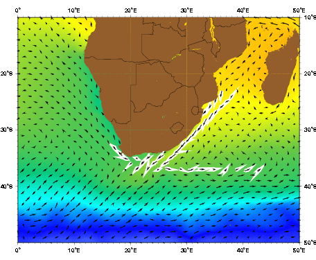
Finally after two decades of cold winters in the North Atlantic studying the Gulf Stream, Phil was ready to move south to study other stages of the warm salty water’s journey north. He and his colleagues investigated the sources of Florida Current, the current that merges into the Gulf Stream. They also traced the fate of the freshwater discharged from the Amazon River and measured the seasonal variations of currents and countercurrents near the equator. Finally he traveled south to the setting of one of the overturning circulation’s most intriguing mysteries, a place where the currents and winds make sailing treacherous. It is the place where the Indian Ocean and Atlantic Ocean meet. The Agulhas Current is the Indian Ocean’s equivalent of the Gulf Stream. It sweeps southwest down the east African coast between Madagascar and Mozambique at speeds of up to five knots, overshooting the tip of South Africa. Westerly winds blowing against the current sometimes generates towering waves capable of breaking supertankers in two. But then instead of continuing west into the South Atlantic, the Agulhas takes a sharp turn to the east called a retroflection. 
The average ship-drift derived surface velocity plot shows two major source regions for the Agulhas current: (1) from the Mozambique channel to the north and along the coast; and (2) from the east including a major contribution from the Madagascar current. The average SST image shows the Agulhas current bringing warm water poleward. Source: Ocean Surface Currents, University of Miami Although the Agulhas Current doesn’t directly carry water from the Indian Ocean into the Atlantic, eddies spinning off the retroflection do. These 400 km wide counterclockwise rotating eddies, called Agulhas rings, contain warm salty water from the tropical Indian Ocean. Smaller clockwise spinning cold eddies also break off from the Agulhas Current along the African coast and move southwest into the Atlantic, often crossing paths and mixing with the warm-water Agulhas rings. These Agulhas rings are of particular interest to Phil and his colleagues. Could they be a major source of the warm salty water that flows north across the equator and enters the Gulf Stream? If the answer is yes, these eddies would form a critical component of the meridional overturning circulation. As part of an international effort to study these eddies, Phil and his colleagues stationed themselves along southwest coast of Africa north of where the Agulhas rings form. Using floats, they tracked some of these Agulhas rings as they made their way west across the South Atlantic to the Brazilian coast and then disintegrated. It’s here that things get complicated. Phil thinks that about half the water from these disintegrating eddies branches south down the South American coast and gets caught up in the South Atlantic subtropical gyre. The rest, he thinks sinks. It then flows north through currents below the surface before reemerging at the equator. Phil thinks that much of this water eventually winds up in the Gulf Stream. Through it all, Phil has also found time to investigate other mysteries. In 1978, he went searching for Benjamin Franklin and Timothy Folger’s original chart of the Gulf Stream. This chart dating from 1769–1770 had been missing for 200 years. Phil had a hunch that because the French held Franklin in such high regard, they were likely to have kept copies. His hunch paid off when he uncovered two copies in the Bibliothèque Nationale in Paris. The charts contain excellent representations of the Gulf Stream and so remain valuable even today. In another project, Phil and his colleague Roger Goldsmith used ship drift data to weigh in on the controversy of where Christopher Columbus first made landfall after crossing the Atlantic. Columbus was originally thought to have landed on San Salvador Island in the Bahamas. However, a 1986 National Geographic article argued that Columbus had likely landed on a different island, Samana Cay. Phil studied the ship’s logs, adjusted for currents, wind, and magnetic variation, and concluded that Columbus’s track brought the ships closest to San Salvador. There are still many uncertainties, however, especially in the magnetic variation, so the controversy rages on. Today, Phil is looking forward to investigating more mysteries. He is hoping to continue his study of the northward flow of warm salty water, but this time in the Caribbean–just as long as it’s not hurricane season. |
