Topex/Poseidon illustration topex-www.jpl.nasa.gov/gallery/gallery.html
NASA's Topex/Poseidon Oceanography Mission Ends01.05.06 "Topex/Poseidon revolutionized the study of Earth's oceans, providing the first continuous, global coverage of ocean surface topography and allowing us to see important week- to-week oceanic variations," said Dr. Mary Cleave, associate administrator for NASA's Science Mission Directorate. "Its data made a huge difference in our understanding of the oceans and their effect on global climatic conditions." Topex/Poseidon data have helped in hurricane and El Nino/ La Nina forecasting, ocean and climate research, ship routing, offshore industries, fisheries management, marine mammals' research, modernizing global tide models and ocean debris tracking. "Topex/Poseidon was built to fly up to five years, but it became history's longest Earth-orbiting radar mission," said Topex/Poseidon Project Scientist Dr. Lee-Lueng Fu of NASA's Jet Propulsion Laboratory, Pasadena, Calif. "It provided, on average, more than 98 percent of the science data it was designed to collect in every 10-day measurement cycle, a remarkable achievement." Its primary phase (lasting 3 years) ended in the fall of 1995 and completed 13 years of successful operation in January 2006. The satellite's pitch reaction wheel, which helps keep the spacecraft in its proper orbital orientation, stalled on October 9, and ground controllers concluded the wheel was not functioning. The satellite remains in orbit 1,336 kilometers (830 miles) above the Earth, posing no threat to the planet.
TOPEX/Poseidon orbits 1,336 kilometers (830 miles) above the Earth's surface. The TOPEX/POSEIDON satellite supplies sea surface height data for much of the world's ice-free oceans. Sea level is measured along the same path every 10 days using a radar altimeter mounted on the satellite. Figure from AVISO. | Jason-1, pictured below, a follow-on oceanography mission, continues Topex/Poseidon's study of ocean circulation affects on Earth's climate.
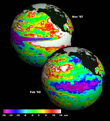
Launched in 1992 to make precise measurements of the ocean surface, TOPEX/Poseidon was watching in 1997 when the largest El Niño in 100 years changed weather patterns a round the world. "TOPEX/Poseidon didn't discover El Niño," says mission scientist Dr. Lee-Lueng Fu, a JPL oceanographer, "but it did give us our first global perspective on this and other short-term climate events such as La Niña. It allowed us to follow their evolution and showed that these events weren't limited just to the tropics. It also gave us evidence of even longer-lasting phenomena." The mission's most important achievement was to determine the patterns of ocean circulation - how heat stored in the ocean moves from one place to another. Since the ocean holds most of the Earth's heat from the Sun, ocean circulation is a driving force of climate. "TOPEX/Poseidon has given us the longest and most complete observations of surface circulation in the deep ocean," says Fu. TOPEX/Poseidon made it possible for the first time to compare computer models of ocean circulation with actual global observations and use the data to improve climate predictions.
Topex/Poseidon's data have been the subject of more than 2,100 research publications; major science and application
How does an altimeter system work? Related links: |