Surface currents located on the western side of the subtropical gyres, so-called western boundary currents, are faster than their eastern counterparts. In fact, they are among the fastest surface currents in the ocean. One reason for the westward intensification of boundary currents has to do with the strengthening of the Coriolis effect with latitude. The Coriolis effect is stronger in the latitudes of the westerlies than in the latitudes of the trade winds. Transport of surface waters toward the western boundary of the ocean basins causes the ocean-surface slope to be steeper on the western side (versus eastern side) of a gyre (in either hemisphere). A steeper ocean-surface slope translates into a faster geostrophic flow on that side of the gyre. 
Click to enlarge. Waters moving in the western boundary currents adjacent to the major gyres (North and South Pacific and Atlantic basins and the Indian basin) transport large quantities of heat poleward from the tropics. Among these boundary currents are the Gulf Stream and the Kuroshio (off Japan), which rank next in volume of water flow to the Antarctic Circumpolar Current. The Southern Hemisphere's western boundary currents include the Agulhas Current (off southeast Africa), the Brazil Current, and the East Australia Current. These currents are weaker than those in the northern ocean basins, in part because western boundary currents require extended land barriers that are generally absent in the Southern Hemisphere. Flows in the major western boundary currents are 50 to 100 times the total water discharged by all the world's rivers. |
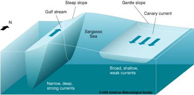
As shown here for the North Atlantic but also true for all ocean basins, the ocean surface slope is steeper on the western side of an ocean basin than on the eastern side. Consequently, surface ocean currents are stronger, narrower, and deeper in all western boundary regions. Note that the vertical scale is greatly exaggerated. Waters in western boundary currents typically move 40 to 120 km (25 and 75 mi) per day. These currents also extend much deeper than most other surface currents, down to a depth of 1000 m (3300 ft) or more. Thus, the strong western boundary currents are so deep that they are deflected by the continental margins, which prevent these currents from flowing onto the shallow continental shelves. Eastern boundary currents, such as the California Current and the Canary Current, are slower, shallower, and wider than the western boundary currents. Similar to the return flow in a household heating system, these currents transport colder waters into the tropics where they are heated and transported poleward in the western boundary currents. Adapted from DataStreme Ocean and |